In 2017, underwater cave explorers Fred Devos, Christophe Le Maillot, and Sam Meacham of CINDAQ found evidence of ancient mining activity while exploring and mapping new tunnels of an underwater cave near Akumal, Quintana Roo, Mexico.
The Maya are known to have actively mined pigment and other minerals from the caves of the Yucatan Peninsula, but the ancient mines discovered by the CINDAQ team are now submerged, indicating that such mineral exploitation occurred thousands of years ago. At the end of the last Ice Age, intrepid miners ventured deep into these tunnels with torches in hand. The navigational markers, mining debris, fire pits and excavation pits they left behind are now entirely underwater.
We dedicate our work to our coauthor, colleague, and friend, Pilar Luna Erreguerena, who passed away on March 15, 2020. Pilar was a pioneer and tireless champion for the study and conservation of underwater cultural heritage in Mexico and around the world, Pilar will be missed by all who knew her and will continue to inspire future generations of diving scientists throughout the Americas.
PLEASE ACCESS THE PAPER VIA THIS LINK: https://advances.sciencemag.org/content/6/27/eaba1219
The research into the site has been led by Pilar Luna Erreguerena and Roberto Junco of the Subdireccion de Arqueología Subacuática del INAH. The CINDAQ dive team created a high grade map of the cave system and documented the site with 3-dimensional modeling of the mine and its many features. Additionally, a 360 degree camera was taken to the site to document it in high resolution. Researchers from Mexico, Canada, and the United States have sampled and analyzed the exposed mineral deposits to learn what resources were being exploited and to radiocarbon date wood from ancient fires to establish when this mine was active.
WHY IT’S IMPORTANT
- The discovery has the potential to help us understand the social and behavioral complexities of the region’s earliest inhabitants.
- This new research shows ochre was of great, if not critical, importance to the culture and lives of Paleoamericans, given they were willing to take such enormous risks to get it. Red ochre is the most commonly identified inorganic paint, used throughout human history. It’s considered to be a key component of human evolutionary development and behavioral complexity. Ochre minerals were collected for use in rock paintings, mortuary practices, painted objects and personal adornment. They may even have had medicinal qualities.
- The mining activity from more than 10,000 years ago also shows the early application of geological principles that were only documented 400 years ago.
- Together with the exploration of Hoyo Negro, where the remains of Naia were found, the exploration of these caves is advancing research techniques, especially using 3D photogrammetry and virtual reality.
- The abundance and diversity of animal and plant remains found in these submerged caves enables scientists to recreate what the environment was like for Ice Age Americans.
CINDAQ is grateful for the support of landowner Adolfo Ruiz-Ortega and his family.
PLEASE NOTE: The models and videos on this page are best viewed on a desktop/laptop computer and not on a mobile device.
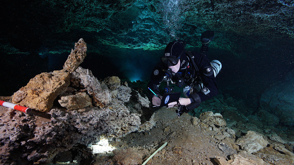
The model above is an area that really was our first clue that something was amiss. The red and white scale is 50cm long. As you navigate the model you can see the clear edge where the floor was broken. The spoil is piled up behind. The color of the rock spoil is red from the ochre that was being extracted. This is just one small area, but it is indicative of the rest of the site. What astounds us is the level of organization and physical effort that would have been necessary to carry out this work, bring wood in for fires, and carry out the mined ochre.
You will have better control navigating the model with a mouse rather than a track pad.
The model above is of another area that demonstrates clear mining activity. To the right side of the model you will see a number of large sized rocks and speleothems piled on the floor. The yellow colored formation in the middle left of the floor would have formed after this area had been mined.
You will have better control navigating the model with a mouse rather than a track pad.
The video above is a fly through of a 1.2 billion point cloud model that covers approx. 175 meters of La Mina at an average depth of approx. 9-10 m. The model is comprised of @9000 photographs taken over @6 dives using a Sony A7S camera and Canon 16-35 mm lens housed in a Nauticam NA-7 housing. The cave was illuminated using two camera mounted Big Blue Black Molly video lights.
The model took about 89 hours to render on supercomputers at UCSD’s Cultural Heritage Engineering Initiative using Agisoft Photoscan software.
The fly through was created on Viscore.
- The value of such models is to allow anyone to virtually ‘visit’ the site without causing any impact.
- In the model you will see the clear and irrefutable evidence of human mining activity. Rock cairns, excavated pits, and mine spoils piled on the sides are all signs of this activity.
- The white square markers you see on the bottom were placed periodically throughout the cave in order to help the modeling software to orient itself.
- We are grateful for the support and expertise of UCSD CHEI, Dr. Falco Kuester, Dr. Dominique Rissolo, Vid Petrovic, Eric Lo, and Danylo Drohobytsky
Research Team
- Arq. Pilar Luna Erreguerena - INAH SAS
- Dr. Roberto Junco - INAH SAS
- Dr. Brandi Lee McDonald - The University of Missouri Columbia
- Dr. Eduard Reinhardt - McMaster University
- Dr. James Chatters - Paleoscience
- Dr. Dominique Rissolo - UCSD Cultural Heritage Engineering Initiative
- Dr. Barrett Rock - The University of New Hampshire
- Eric Lo - UCSD Cultural Heritage Engineering Initiative
Exploration Team
- Fred Devos
- David Dusek
- Vicente Fito *
- Gabriel Gasca *
- Martin Gaspar *
- Osama Gobara
- Chris Le Maillot
- Sam Meacham
- Rogelio Mier *
- Wiliam Ortega *
- * original explorers
Boxfish 360˚ Camera Team
- Fred Devos
- Sam Meacham
- Russell Hughes
Mapping Team
- Benjamin Beyer
- Angelica Chimal Teh
- Fred Devos
- David Dusek
- Peter Sprouse
- Mathijs Geenen
- Osama Gobara
- Nicole Heuer
- Larry Keele
- Chris Le Maillot
- Gideon Liew
- Anke Löbel
- Sam Meacham
- Alison Perkins
- Cameron Russo
- Dijana Stuper
- Flip Vernooij
- Cholo de Villa
- Miko Zuleto
Photogrammetry Team
- Fred Devos
- David Dusek
- Mark Garland
- Chris Le Maillot
- Sam Meacham
- Alison Perkins